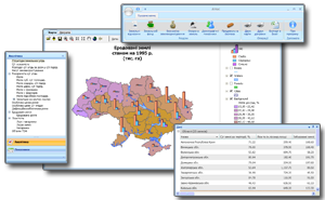
The designed
multifunctional electronic atlas of land and land relations in Ukraine fully
satisfies the list of today's tasks in the field of land and land resources.
Interface of the electronic atlas is focused on the user with initial training
to work with the computer. But the advanced user has the ability to customize
to your requirements this atlas and presentation. The project also included the
methods and rules to populate a database of available data sources. Developed
software supports the ability to complement the atlas with new information
blocks as tabular and geospatial information.
Work on the project
was carried out in 2009.

 The designed
multifunctional electronic atlas of land and land relations in Ukraine fully
satisfies the list of today's tasks in the field of land and land resources.
Interface of the electronic atlas is focused on the user with initial training
to work with the computer. But the advanced user has the ability to customize
to your requirements this atlas and presentation. The project also included the
methods and rules to populate a database of available data sources. Developed
software supports the ability to complement the atlas with new information
blocks as tabular and geospatial information.


